Published on 26/03/2022
In the age of technology it’s difficult to appreciate how crews in years gone by were able to successfully navigate vast oceans, travelling all over the world with just a paper map to guide them. It’s even harder for most to understand that despite the emergence of sophisticated radar and satellite technology in recent years, many vessels still rely on or incorporate the use of paper maps today.
In maritime circles, the use of complex paper maps and traditional course-plotting techniques are commonplace. These are skills that are essential and highly valuable, ensuring that crews always have a basic method of navigation to hand and an intricate understanding of course plotting.
But as our oceans become busier and the world of shipping grows more complex, an advance in technology that preserves the valuable course-plotting skillset of crews whilst offering enhanced safety and efficiency was needed. This is how ECDIS Charts came to be.
What is an ECDIS Chart?
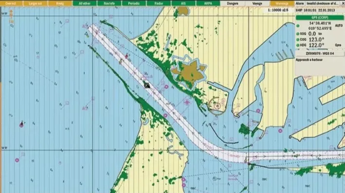
An Electronic Chart Display and Information System (ECDIS, for short) is a fairly recent development in the navigational chart system used by sea-going vessels, in particular larger naval vessels, tankers and container ships.
To understand exactly what an ECDIS Chart does and how it works, it’s important to first look at how things were done for hundreds of years prior to their conception.
In years gone by before starting any voyage, you’d need a stack of paper maps, a compass and a pencil. Exclusively using paper maps and charts (which could not cater to crucial updates on a daily or hourly basis), crews would manually plot a course often using the benefit of past experience and any daily reports to influence their directions. This was a highly effective method despite its primitive nature and the opportunity for human error – but it left vessels open to a wide variety of potential dangers and unexpected issues, especially in the commercial realm where time is money and an increased number of vessels on the water impose a greater risk.
Using innovative, sophisticated technology ECDIS essentially streamlines and expands upon the basics of traditional plotting techniques, offering significantly better navigation and safety features with the use of digital integrations and location technology, offering ‘eyes and ears’ in real time. They also feature full-colour digital displays which can show multiple sources of information at a glance.
This navigational information system is powered by a number of integrations including GPS, radar and Echo Sounder and incorporates key information in real time from sources such as Tide Tables, Sailing Directions, weather and automatic vessel identification. ECDIS capabilities include:
*Location pinpointing and route planning
*Route monitoring
*ETA computation
*ENC updates
*Continuous data recording
ECDIS was developed to work alongside paper charts, providing an added layer of safety and security which consolidates many of the navigational processes seamlessly. However ECDIS equipment that complies with SOLAS requirements can be used as an alternative to paper charts.
How do ECDIS Charts work?
ECDIS charts are complex and are often modified with unique capabilities depending on the vessel they are installed within.
At a basic level, ECDIS is a computer-based system incorporating robust, specialist electronic navigation software that operates in tandem with a variety of other navigation tools to offer crew a highly accurate and constantly updated impression of their route, including identification of risks and obstacles as they arise. ECDIS systems offer intelligent automation that vastly enhances safety and provides an efficient way to plan a voyage and maintain ship safety along the way. ECDIS also constantly records data which can be used to determine the cause of an event or incident during a voyage.
Why are ECDIS Charts important?
ECDIS Charts were introduced as an industry standard through SOLAS Chapter 5 and the IMO’s guidelines, along with Port State Control Requirements. They are now essential on board many commercial vessels.
The advantages of ECDIS Charts over traditional paper charts are numerous, including:
*Real-time information processing and display
*Navigational information at a glance
*Dangers clearly highlighted
*A simpler and more straightforward passage planning process
*Intelligent integration of other navigational equipment such as AIS and ARPA
*More accurate ETA provision and chart tailoring and amendment
*Enhanced navigational safety
Although it is not their primary function, ECDIS systems also maximise profit through reducing the margin of error that often needed to be left by traditional plotting and navigation methods, due to their lower level of precision. With an ECDIS on board, ships can identify and select the safest, swiftest route, avoid scheduling difficulties caused by inaccurate ETA data and even carry more cargo.
Selecting a reliable ECDIS
Not all ECDIS systems are created equal. From a safety and performance perspective choosing a reliable and robust ECDIS system is essential – but from a legal standpoint it also ensures that you are fully compliant with the latest regulations.
At Martek Marine we’re trusted worldwide to provide the best in ship safety systems and remain committed to sourcing cutting-edge technology which remains at the forefront of marine safety innovation – which is why we are an authorised distributor of UKHO ADMIRALTY ECDIS Charts, including AVCS charts and publications.
Discover more about Admiralty ECDIS Charts here.